-
Please be sure to read the rules and adhere to them. Some banned members have complained that they are not spammers. But they spammed us. Some even tried to redirect our members to other forums. Duh. Be smart. Read the rules and adhere to them and we will all get along just fine. Cheers. :beer: Link to the rules: https://www.forumsforums.com/threads/forum-rules-info.2974/
You are using an out of date browser. It may not display this or other websites correctly.
You should upgrade or use an alternative browser.
You should upgrade or use an alternative browser.
FUNNY PICTURE THREAD II
- Thread starter Melensdad
- Start date
NorthernRedneck
Well-known member
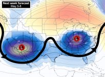
Heads up! THIS is coming next week! Do you see what we see?
What you should be seeing is the Greek letter "omega", or "ω". The so-called "omega block" pattern gets its name because the jet stream traces a ω pattern. Those two sagging circles are low pressure systems, which spin counterclockwise. Farther north, a high pressure system can be seen in red spinning counterclockwise.
The opposing spin of each system means the three – the low, high and low – are like interlocking gears. They don't budge, spinning and feeding into each others' spin for days.
Beneath the low pressures, expect unsettled weather, cooler temperatures and cloud cover.
Beneath the high, in the red, southern Canada and much of the northern U.S. should see sinking air, bright skies and above-average temperatures.
There's a chance the western low may pump north moisture, setting the stage for severe weather over the High Plains on Monday, Tuesday and Wednesday. I'd be closely watching West Texas, eastern New Mexico and perhaps western/central Oklahoma.

NorthernRedneck
Well-known member
Not 2 slices. 2 packages!


