
-
Please be sure to read the rules and adhere to them. Some banned members have complained that they are not spammers. But they spammed us. Some even tried to redirect our members to other forums. Duh. Be smart. Read the rules and adhere to them and we will all get along just fine. Cheers. :beer: Link to the rules: https://www.forumsforums.com/threads/forum-rules-info.2974/
You are using an out of date browser. It may not display this or other websites correctly.
You should upgrade or use an alternative browser.
You should upgrade or use an alternative browser.
tent
- Thread starter daedong
- Start date
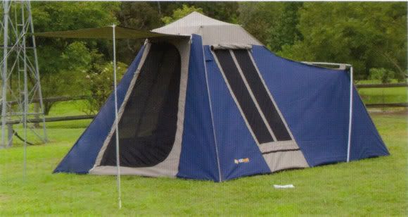
They are common in Australia. Cheap, generally made in China, Brands we have here are OZtrail, Explorer touring tent.
9, 9 Plus or 10?
daedong
New member
9 plus is what I am looking for. These tents take about 3 mins to erect.
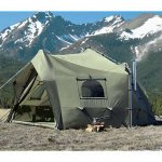
Thanks for that Dave, that tent is bigger than I want, this one is getting closer. http://www.cabelas.com/cabelas/en/te...t550002&r id=
Thanks for that Dave, that tent is bigger than I want, this one is getting closer. http://www.cabelas.com/cabelas/en/te...t550002&r id=
I was actually going to suggest that one also, but I don't think it would hold up to some of the winds you might experience during your trip.this one is getting closer.
Dave, what sort of wind strength are we talking at that time of year in NV, UT, CO, NE, KS.
Gusts of 55KPH (35MPH) or higher. Steady winds of 30KPH (20MPH) for 24-36 hours straight.
Not to mention the 300MPH tornados (I think they are cyclones in Oz.)
daedong
New member
Well if we get hit by a tornado I don't think it will matter what tent we have.
I found a manufacturer for those tents. Now surely we have an entrepreneur here at FF that can start to import them, I will buy the first one.
http://www.ecplaza.net/tradeleads/seller/4392576/family_tent_ft5002.html
I found a manufacturer for those tents. Now surely we have an entrepreneur here at FF that can start to import them, I will buy the first one.
http://www.ecplaza.net/tradeleads/seller/4392576/family_tent_ft5002.html
I like the looks of the LLBean tents:
http://www.llbean.com/webapp/wcs/st...00106&cat4=1096&shop_method=pp&feat=500106-tn
plus they are pretty much guaranteed for life.
http://www.llbean.com/webapp/wcs/st...00106&cat4=1096&shop_method=pp&feat=500106-tn
plus they are pretty much guaranteed for life.
Vin,
Can't help with the tent but have a question and thought for you.
How much "stuff" are you going to buy in the USA for your trip? Are you taking it all home with you?
My thought is to see if a FF member near your arrival point (on the west coast) can receive the packages for you and hold until you arrive.
At the end of your trip, have someone on the east coast hold "stuff" you don't want to take back with you. You then list the "stuff" you're not taking back with you in the classifieds section of the forum.
Example:
You buy a tent at Cabela's.
Have it shipped to a FF member in California.
List it in the Classifieds section of the forum and say it's available approximately November 1, 2008.
Someone on the forum buys it. Money can be sent to you or maybe the person in California who holds it for you.
You use it on your trip.
At the end of the trip, a FF member near your departure city gets the tent from you and arranges mailing to the buyer.
daedong
New member
I think I'll probably buy everything when I get there. At this stage my first stop will be with my cousin, so if I do pre buy I'll get it shipped there. Because I won't be bringing it home with me, the bulk of gear will only be cheap equipment, so at this point in time I am not too fussed about selling it. However, if I do buy any expensive gear I may be looking for someone to sell it for me.
I think I'll probably buy everything when I get there. At this stage my first stop will be with my cousin, so if I do pre buy I'll get it shipped there. Because I won't be bringing it home with me, the bulk of gear will only be cheap equipment, so at this point in time I am not too fussed about selling it. However, if I do buy any expensive gear I may be looking for someone to sell it for me.
The problem with cheap equipment is it lasting. You were talking a number of weeks where you'll be doing a mix of camp and hotels. I fear "cheap" would not last very long.
One option if you did get a better quality gear, is someone towards the end of you trip could sell it on Criags list or local classifieds...
I've camped with cheap stuff. It's ok for a weekend trip, but for more use, it just does not hold up. And, for a trip like yours, you will want to be comfortable.
Galvatron
Spock and Galvatron < one and the same
have a look at this .....new in our shops in the uk loads of space and the price is cheap.....might pick up one of these myself.
http://www.argos.co.uk/static/Produ...ng+and+caravanning>C$cip=1500011166.Tents.htm
http://www.argos.co.uk/static/Produ...ng+and+caravanning>C$cip=1500011166.Tents.htm
daedong
New member
When is your trip?
I have a pretty good idea of what the seasonal conditions are liklely to be in Ks & Ne.
Sept/Oct 08 http://www.forumsforums.com/3_9/showthread.php?t=13377
OK.
I read the other thread.
AAA does have nice big maps.
On the other hand, a Rand McNalley US Atlas for $7 gives you a good overview of the major and most minor highways and the fine tuning can be done using google maps/mapquest/pick your favorite.
I-40 across Arizona and New Mexico is absolutely stunning around sunrise and sunset, ties into I-44 at Oklahoma City, which ties into I-70 at St Louis which will get you to DC. (alternatively, you can also pick up I-64 in St Louis and it connects to I-70 in Maryland but goes through "prettier" country - but sounds like fewer of the folks you'd want to see on the trip)
I-70 crosses the entire US, as does I-80 - just by different routes. Again, depends on who you want to roll near.
Kansas and Nebraska in late September/early October are still quite warm on average, with chance for heavy rain and possible frost. (seriously, I've seen it go from sunny and 25C to snowing and -2C over the course of about 4 hours starting at noon)
hints about US highway numbering system - even numbers run E-W, odd numbers run N-S. Smallest odd number is highway 1 on the California coast, smallest even interstate is near the Mexico border.
most states number their interstate exits by mile marker. (if you're at mile marker 68 going East and the sign says gas at exit 80, you'll have about 12 miles to go)
oh, yeah - the pyramid tents at Cabela's are pretty nice, at reasonable cost, and they set up real fast, but they have a center pole which eats some of the available floor space. (I suspect they're similar to what Kimi linked)
good luck!
US "Highways" and US "Interstates" are a little bit different. You don't need to memorize any of this, there will be no test, but here are the schemes for both.
Interstate north-south routes have odd numbers, with numbers increasing from west to east.
Interstate east-west routes have even numbers, with numbers increasing from south to north.
Interstate highway routes have one- or two- digit numbers.
North-south interstates ending with a 5 and east-west interstates ending with a 0 are typically major cross-country routes.
A three-digit interstate always ends with the two-digit number of the main interstate it loops off from, except I-238.
Three-digit road numbers beginning with an even number are either beltways that go around a city or freeways that go through a city.
Three-digit road numbers beginning with an odd number branch off the main interstate.
U.S. highway north-south routes have odd numbers, with numbers increasing from east to west.
U.S. highway east-west routes have even numbers, with numbers increasing from north to south.
U.S. highway east-west routes ending in 0 tend to be cross-country routes.
Three-digit U.S. routes contain the two digits of their parents routes, but there is not an odd and even number system.
P
Pigtails
Guest
I think a compass would be easier.. And of course, a good US hwy map
And of course, a good US hwy map
P
Pigtails
Guest
Silly, we don't need to ask for directions, WE HAVE THE MAP.
Bob is looking a tad singged from just being burnt by pigtails. I say drive around in a 4x4 and sleep in that!  Screw the tent.
I say drive around in a 4x4 and sleep in that! Screw the tent.