Any fans of Andy Griffith & his shows about Mayberry?
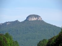
Mount Pilot was the big city in his series, which is based loosly on Mt Airy, NC. Mt Airy is a town within viewing distance of Pilot Mountain, which is an unusal rock mountain with a crest that juts straight up near the peak.
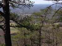
Took a hike up there with the family. I made it all the way up, but only after abandoning the Lovely Mrs_Bob and Melen on the trail about 1/3rd of a mile below the top The top 2.2 miles are pretty rough and steep. Parks service lists that trail area as 'strenuous' the prior 3+ miles were listed as 'moderate' for hiking. We picked up a stray 24 year old boy (I guess that would be 'young man')along the route who was hiking alone, he and I continued to the top together.
Weather started out cool, about 50 degrees + breezy and we were walking in the shade of the not yet leafed out trees. As the elevation changed so did the conditions. Sun came out, temps warmed up to the lower 60's, breeze became calm and the trees became pine trees. Stripped off a layer and was hiking in a short sleeve shirt. Backpack had rain pants, rain jacket, fleece jacket, first aid kit, 2 liters of water and some food. Ended up not eating the food as we finshed our return trip back down by about 2pm so we grabbed a late lunch at a restaurant. Rainpants never came out, never rained. Rain jackets were used as they double as wind-breakers and were needed for the first 90 minutes of the ascent. Fleece was needed in the early part too, just as a bit of insulation. But when the sun came out the cool wind stopped and the temps came up about 10 to 15 degrees.
Tested out the new camera clip that I wrote about in another thread. Best system I've ever laid my hands on
Mount Pilot was the big city in his series, which is based loosly on Mt Airy, NC. Mt Airy is a town within viewing distance of Pilot Mountain, which is an unusal rock mountain with a crest that juts straight up near the peak.
Took a hike up there with the family. I made it all the way up, but only after abandoning the Lovely Mrs_Bob and Melen on the trail about 1/3rd of a mile below the top
The top 2.2 miles are pretty rough and steep. Parks service lists that trail area as 'strenuous' the prior 3+ miles were listed as 'moderate' for hiking. We picked up a stray 24 year old boy (I guess that would be 'young man')along the route who was hiking alone, he and I continued to the top together. Weather started out cool, about 50 degrees + breezy and we were walking in the shade of the not yet leafed out trees. As the elevation changed so did the conditions. Sun came out, temps warmed up to the lower 60's, breeze became calm and the trees became pine trees. Stripped off a layer and was hiking in a short sleeve shirt. Backpack had rain pants, rain jacket, fleece jacket, first aid kit, 2 liters of water and some food. Ended up not eating the food as we finshed our return trip back down by about 2pm so we grabbed a late lunch at a restaurant. Rainpants never came out, never rained. Rain jackets were used as they double as wind-breakers and were needed for the first 90 minutes of the ascent. Fleece was needed in the early part too, just as a bit of insulation. But when the sun came out the cool wind stopped and the temps came up about 10 to 15 degrees.
Tested out the new camera clip that I wrote about in another thread. Best system I've ever laid my hands on