
-
Please be sure to read the rules and adhere to them. Some banned members have complained that they are not spammers. But they spammed us. Some even tried to redirect our members to other forums. Duh. Be smart. Read the rules and adhere to them and we will all get along just fine. Cheers. :beer: Link to the rules: https://www.forumsforums.com/threads/forum-rules-info.2974/
You are using an out of date browser. It may not display this or other websites correctly.
You should upgrade or use an alternative browser.
You should upgrade or use an alternative browser.
What the hell is going on?
- Thread starter muleman
- Start date

Hell the weather channels is saying we could get 6-8 inches of snow Sunday into Monday. Hard to believe when I was sweating in a T shirt yesterday while working in the garden. Was hoping to put some more stuff out in the garden this coming week but not with the cold they are predicting for next weekend. Hope the peas survive as they are getting going and looking nice. My early lettuce got cooked from being too hot in the boxes this past week.
I sure hope it misses you and they are wrong.Hell the weather channels is saying we could get 6-8 inches of snow Sunday into Monday. Hard to believe when I was sweating in a T shirt yesterday while working in the garden. Was hoping to put some more stuff out in the garden this coming week but not with the cold they are predicting for next weekend. Hope the peas survive as they are getting going and looking nice. My early lettuce got cooked from being too hot in the boxes this past week.

We started our garden a week ago and last night we were really concerned because of freeze warnings but we lucked out. It only got down to 37 and is allready 48 at 8:30. I think our freeze worrys are over according to the long term forcast. Now I only have to worry about the damn critters eating everything.

Well the first round of rain is here already and we direly need it. The temp shift will be hard on things that are budded out.I took the skid steer and loaded some good dry slab wood into the wood shed so I will have enough to burn the newer wood. Will take some serious heat on Monday if it only gets to 36 for a high. Wife is having a fit about her flowers and lilacs since they survived 2 cold nights already. It looks like it will be a northeaster that will bring the snow to us and all the interior NE.
We left at 11:00 it was 62F and till we got back at $ it had dropped to 43. Then the beeper started going off a minute ago:
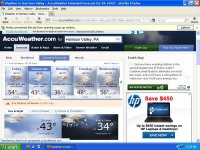
Harrison Valley, PA Weather Advisories, Watches & Warnings
WINTER STORM WATCH
in effect until Tuesday, Apr 24, 12:00 PM
...WINTER STORM WATCH IN EFFECT FROM SUNDAY EVENING THROUGH TUESDAY MORNING...
THE NATIONAL WEATHER SERVICE IN STATE COLLEGE HAS ISSUED A WINTER STORM WATCH...WHICH IS IN EFFECT FROM SUNDAY EVENING THROUGH TUESDAY MORNING.
* LOCATIONS...NORTHERN AND WESTERN MOUNTAINS OF PENNSYLVANIA...INCLUDING THE LAUREL HIGHLANDS.
* HAZARD TYPES...HEAVY SNOW...ACCOMPANIED BY INCREASING NORTHERLY WINDS LATE SUNDAY NIGHT AND MONDAY.
* ACCUMULATIONS...IN EXCESS OF 6 INCHES...WITH UP TO ONE FOOT POSSIBLE ACROSS SOME OF THE HIGHER TERRAIN.
* TIMING...SUNDAY NIGHT THROUGH TUESDAY MORNING.
* IMPACTS...EXTREMELY HAZARDOUS TRAVEL FROM PERIODS OF HEAVY SNOW AND POOR VISIBILITY. THERE IS THE POTENTIAL FOR NUMEROUS DOWNED TREES CAUSING POWER OUTAGES...BEGINNING LATER SUNDAY NIGHT.
* WINDS...NORTH TO NORTHEAST 10 TO 20 MPH WITH GUSTS UP TO 25 MPH SUNDAY NIGHT...INCREASING TO 15 TO 25 MPH WITH GUSTS TO 40 MPH MONDAY.
* TEMPERATURES...30 TO 35 DEGREES.
* VISIBILITIES...BELOW ONE HALF OF A MILE AT TIMES.
PRECAUTIONARY/PREPAREDNESS ACTIONS...
A WINTER STORM WATCH MEANS THERE IS A POTENTIAL FOR SIGNIFICANT SNOW...SLEET...OR ICE ACCUMULATIONS THAT MAY IMPACT TRAVEL. IN ADDITIONAL...SINCE MANY TREES ALREADY CONTAIN NEAR FULL-FOLIAGE... THERE IS THE POTENTIAL FOR MANY DOWNED TREES AND NUMEROUS POWER OUTAGES FROM THE COMBINED EFFECT OF THE HEAVY WET SNOW AND WIND. STAY TUNED TO NOAA WEATHER RADIO OR YOUR FAVORITE SOURCE OF WEATHER INFORMATION FOR THE LATEST UPDATES. ADDITIONAL DETAILS CAN ALSO BE FOUND AT...WEATHER.GOV/STATECOLLEGE.