In a few months there will be Tundra growing right up to this well casing. I apreciate having an 'ally' on the soap box personally. At a mojority of our well sites there will be little or no sign at all of damage to the surronding area. I'll save the story of the DEP (Dept. of Envriromental Protection) Guy for another day when I get some time.

-
Please be sure to read the rules and adhere to them. Some banned members have complained that they are not spammers. But they spammed us. Some even tried to redirect our members to other forums. Duh. Be smart. Read the rules and adhere to them and we will all get along just fine. Cheers. :beer: Link to the rules: https://www.forumsforums.com/threads/forum-rules-info.2974/
You are using an out of date browser. It may not display this or other websites correctly.
You should upgrade or use an alternative browser.
You should upgrade or use an alternative browser.
Alaska Cat Trains
- Thread starter Lyndon
- Start date
For those of you that wanted to know where the Prudhoe Bay complex was to find it with Google Earth or a similar sattelite locator: 70 degrees, 21 Min' N, and 148 Deg, 50' W. The northern most part of the current Oil development in the Northwest Ter. is: 69 Deg, 20' N, by 126 deg, 45' W. The Canadian oil fields extend from North central BC all the way into the Yukon and Northwest territories but much of it has not been developed yet.
Re: And now for the "Rest of the Story"
Noon, -20 and blowing. The minus 20 part isn't so bad, but throw in a bit of wind and things get tough. Visability is about 200 feet. If I don't finish this entry it's because they declared "Phase 2" and we will all have to Convoy back to the Camp.
SO... I like to start stories out with So because English teachers hate it! Still a bit of the Rebel left in me from my high school days.
So this guy in Texas, employee of a certain Government Environmental Protection agency that we will leave UnNamed(Not the EPA), calls up his college buddy who is in Prudhoe and works for the same agency, and starts grilling him about the Oil operations up here. In the course of their conversation it comes to light that he has generated an article about the alaska oil operations but hasn't published it yet. So the guy in Alaska, who as previously stated, also works for the same Federal Agency ask's his college buddy in Texas to send him a copy of what he wrote. They FAX it through. After glancing over the material the Fed in Prudhoe calls his buddy in Texas back up and convinces him NOT to publish just yet. He further makes all the proper arraingements to have his buddy flown up to Alaska. He arrainges a local Native Pilot that is fimiliar with the Prudhoe area to fly the guy all over the "Slope"(Nickname for Prudhoe). One of the things they were looking for was where the previous winter a major Ice Road to a new development site had been the previous winter. But it's summer and even the experienced Native Pilot can't find where the Ice road was. The Government guy goes back to Texas and tears up the article, seems his little tour of what Really happens here changed his whole outlook on Alaska and it's Oil Companies. And I got the story "Straight from the Horses Mouth", from the college buddy/Federal Government Guy here, so it's likely that it hasn't been too embelished.
But this isn't what usually happens. I have seen on TV and in major Newspapers, articles that had practally no truth in them, and generally they were generated by people that had never been to Alaska. Prior to working here I had no Idea that the 'media' was guilty of so much false reporting. Recently a major news reporting channel showed pictures of an environmental event that happened at another time and place IMPLYING that they were pictures of a Current event which was unrelated. And all this with NO disclaimer.
Definately DON'T BELIEVE EVERYTHING YOU READ!
Re: And now for the "Rest of the Story"
Lyndon, thanks for confirming what so many of us have guessed to be true for so long.
So which news agency was this?
Lyndon, thanks for confirming what so many of us have guessed to be true for so long.
Lyndon said:Recently a major news reporting channel showed pictures of an environmental event that happened at another time and place IMPLYING that they were pictures of a Current event which was unrelated. And all this with NO disclaimer.
So which news agency was this?
ALL of THEM Bob. All of them!
So far there are 45 pictures on this thread of the Forum. All of the ones I posted are of the Prudhoe Oil Fields, but those posted by *MTMOGS, not only are superior pictures, they give you a real fieling for what it's like along the 800 Mile Alaska Pipeline. The Canadian terraine is so similar, trees and all, that looking at these pictures reminds me of specific locations along the Pipeline. Many of these areas are 'Off-Limits' to civilians, almost entirely having to do with Liability. These pictures provide a very good view of what it really looks like that many people will not get the oppertunity to see.
I am amazed at how many people think Alaska is one huge Artic waste land. Its one of our most Beautiful States! Thanks for your comments LYNDON. Its good to hear the truth. Keep the pictures coming in please.
It would appear that the Geophysical guys have given up on Bombardier. Their favorite all around snow cat seems to be TUCKER.Even though they have Hagglunds, they seem to favor the TUCKER's. I'm beginning to side with the Tucker's myself. The Cat Trains were too far off the road to get any good pictures today. Yesterday, with the wind chill it was -63 but this didn't seem to slow down the Cat Train crews any. They just "Keep On Cattin".
B_Skurka said:I wonder what type of truck that is that has the white cab over engine, red cargo container with the mattracks? Its the truck parked next to the big Case IH tractor in the last photo.
My guess looks like those are Western Geophysical units
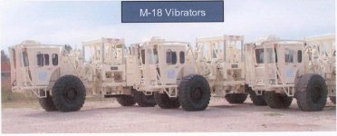
Most likely Mertz Model 18 Vibe Carriers with the Terra Tires Removed and fitted with aftermarket track units.

I decided to walk out in their tracks and get some close-up. It's only -32, but there is a bit of wind and BOY was it a cold walk! I had on my arctic parka and a Hard hat with a liner, but no Arctic Bib's. In the 20 minutes I was out ole jack frost got a good bite on my lungs and cheeks!
with a liner, but no Arctic Bib's. In the 20 minutes I was out ole jack frost got a good bite on my lungs and cheeks!


1975 Snow trac
New member
Those white track rigs are Vibe trucks (Vibration truck). There is a metal pad in between the rear and front tracks that are operated by hydraulics’. The pads come down and shake the ground by a signal sent from the recorder shack once the trucks are in position.
The geo phones pick up the sound waves from the ground and then sends the data to the recorder shack through miles of cable.
When I did that job the Vibe and Jug trucks (cable hauling truck) where Nodwells. I'm not sure who makes the new vibe trucks.
We used the Terra Tuckers for trouble shooting the cables and geo phones. They would go allot faster and smoother than the old nodwells for sure.
Mike
1975 Snow trac
New member
You can see the metal vibe pad in picture 76.
Those Vibe trucks have two diesel motors. One in the rear to run the pad and one in the front or middle. That one is to run the drive system.
Post number 78 is a Jug truck (Cable and crew truck).
Those Vibe trucks have two diesel motors. One in the rear to run the pad and one in the front or middle. That one is to run the drive system.
Post number 78 is a Jug truck (Cable and crew truck).
Thanks Lyndon for the great close-up shots of those vibroseis unit track systems. Those are pretty spectacular machines. The O&G industry has certainly benefitted from tracked vehicle technology.
Thanks also to 1975 SNOW TRAC for the introduction to seismic data acquisition. The purpose of gathering the seismic data is of course to gain a picture of the subsurface for the purpose of locating potential oil and gas accumulations. O&G companies spend loads of $$ on this technology. I'm not sure of the cost of data acquisition on the north slope, but onshore 3D seismic costs range from a low of ~ $20,000 per square mile in Oklahoma/West Texas to more than $500,000/sq. mi. in remote locations with tough terrain. Where terrain is accessible by vibrator trucks like the ones Lyndon has photographed, costs are relatively cheap (although nothing on the slope is cheap). Terrain that prohibits access of these vehicles requires use of heliportable multi-piece rock drills to drill shotholes for explosives in order to produce the acoustic impulse instead of the vibe units. Helicopter costs ($10's of thousand of $$ per hour) rapidly drive up the cost of these operations.
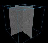
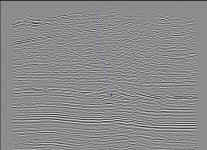
"3D seismic" data is commonly acquired nowadays and yields a 3-dimensional volumetric image of the subsurface as opposed to just a 2d slice. This is high effort, high $$ acquisition, where vibe units or dynamite charges are typically spaced in a rectangular grid generally around 100' x100' m/l over the ground area above the subsurface target. Field acquisition is followed by a lot of computer-intensive digital signal processing to yield a 3d seismic data volume like the one shown below acquired in the Alberta foothills. The bottom pic is a vertical slice through that survey showing the position of a well we drilled to make a natural gas discovery and ultimately a producing gas field. Depth to the bottom of the well is ~13,000'. This would not be possible without the use of seismic data. The guys out in the field with their buggies and tracked vehicles, in snow, swamp, and desert, are indispensible in the process. This is often tough work under the worst conditions and under time/cost/safety pressures. I certainly appreciate their efforts.
Thanks also to 1975 SNOW TRAC for the introduction to seismic data acquisition. The purpose of gathering the seismic data is of course to gain a picture of the subsurface for the purpose of locating potential oil and gas accumulations. O&G companies spend loads of $$ on this technology. I'm not sure of the cost of data acquisition on the north slope, but onshore 3D seismic costs range from a low of ~ $20,000 per square mile in Oklahoma/West Texas to more than $500,000/sq. mi. in remote locations with tough terrain. Where terrain is accessible by vibrator trucks like the ones Lyndon has photographed, costs are relatively cheap (although nothing on the slope is cheap). Terrain that prohibits access of these vehicles requires use of heliportable multi-piece rock drills to drill shotholes for explosives in order to produce the acoustic impulse instead of the vibe units. Helicopter costs ($10's of thousand of $$ per hour) rapidly drive up the cost of these operations.
"3D seismic" data is commonly acquired nowadays and yields a 3-dimensional volumetric image of the subsurface as opposed to just a 2d slice. This is high effort, high $$ acquisition, where vibe units or dynamite charges are typically spaced in a rectangular grid generally around 100' x100' m/l over the ground area above the subsurface target. Field acquisition is followed by a lot of computer-intensive digital signal processing to yield a 3d seismic data volume like the one shown below acquired in the Alberta foothills. The bottom pic is a vertical slice through that survey showing the position of a well we drilled to make a natural gas discovery and ultimately a producing gas field. Depth to the bottom of the well is ~13,000'. This would not be possible without the use of seismic data. The guys out in the field with their buggies and tracked vehicles, in snow, swamp, and desert, are indispensible in the process. This is often tough work under the worst conditions and under time/cost/safety pressures. I certainly appreciate their efforts.
Attachments
Considering that the forum is primarily concerned with Snow Cats, this has been a quite informative site about Oil & Gas development. I've certainly learned alot. This 'insider' look is definately more detailed that anything I've seen in magazines like National Geographic or Scientific American. Keep e'm coming!
And less biased as well! Glad you guys are educating us. Keep it up.
Thanks for the spectacular thread.
All sno-cat enthusiasts should know where their gasoline/oil/grease comes from. Everybody else ought to know as well. It should be known (but I suspect not obvious to all) that plastics/synthetics also come from petroleum . "Patagucci" clothing, for example, is made possible from extractive industries (read petroleum)..............Remember the pictures of "Julia Butterfly", the all natural american girl protecting "Luna"......who was often pictured in "fleece" clothing and hanging from NYLON slings/ropes in the redwood tree?
As a degreed "rock-licker" (geologist) that went bad (turned into a hydrogeologist), I have worked from the southern tip of Peru to N. of the Arctic Circle helping "industry" extract minerals in a responsible manner. I too, have taken it upon myself to educate others as to what really goes down to bring products into peoples homes.
Thanks again for the great thread.
"What our school system needs is a moment of science and reality"


