Vance
Member
Hi,
This is not my story but it took place just across the valley from my property in Soda Springs, CA. I was inspired by Lyndon's GREAT stories about snowcats and had to dig this one up. This one also relates to using DoD "technology" in the search...
Hope you enjoy,
Vance
P.S. TNSAR is the Tahoe Nordic Search and Rescue Team based near Lake Tahoe.
Sunday, February 13, 2005
Story time with Uncle Tony
I got this email from Tony the other day about the search and rescue mission he went on last week. It's amazing stuff. Keep in mind that he volunteers for this.
And, if you're wondering if this is for REAL... it is. There is also more info in the local rag article here:
http://www.sierrasun.com/apps/pbcs.dll/article?AID=/20050209/NEWS/50209007
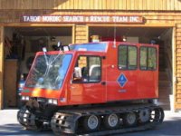
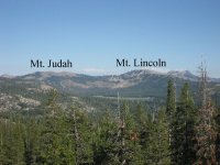
And, here is a pic of the cat and my view of Mt. Linconln from across the way:
This is not my story but it took place just across the valley from my property in Soda Springs, CA. I was inspired by Lyndon's GREAT stories about snowcats and had to dig this one up. This one also relates to using DoD "technology" in the search...
Hope you enjoy,
Vance
P.S. TNSAR is the Tahoe Nordic Search and Rescue Team based near Lake Tahoe.
Sunday, February 13, 2005
Story time with Uncle Tony
I got this email from Tony the other day about the search and rescue mission he went on last week. It's amazing stuff. Keep in mind that he volunteers for this.
SUNDAY 6 AM AT HOME FINISHING DINNER
The phone rings its my friend Fire Captain Ray O'Brien calling from the local fire station. "Scoop, I just picked up an Airport Radio transmission on our police scanner. Possible plane down. Reno, Sacramento, and Oakland International Airports are triangulating its last radar blips. It tentatively looks like it might be for real and close... better get ready."
Ten minutes pass, I'm dressing into winter search clothes and my pager goes off. "Placer County Sheriffs Department requesting a TNSART turn out at Royal Gorge Ski Resort Summit Station parking lot. Field deployment at 7:30 PM.....DOWN AIRPLANE!
I reached the Tahoe City TNSAR Team Garage at 6:30 PM. Several of the guys beat me there are were suiting up and pulling out gear, transceivers, ELT (emergency locator transmitter) radio signal detection equipment and our SAR truck. I connected the suburban to the triple axel(UGH!, what a brick)trailer upon which is loaded our NEW Snowcat. What a kick-ass machine and off we went. About a 40 minute trip to the staging area and a nasty pull over Donner Summit. The Suburban weights about 6,000 lbs. the Cat and trailer about 8,000. lbs ...do the math. A slippery trip over the top with poor visibility and black ice patches. Reaching Royal Gorge we immediately off-load the cat and went into the main lodge to meet the Sheriff Departments Sergeant Fred Carey. We have a lot of respect for Fred. He's been our Sheriff's Department coordinator only two years. He acknowledges our experience and gives us a very, VERY long leash. The initial plotting of the planes last moments, provided by the three airports, placed it some 5 miles southwest from us and in a probability zone of 2X5 miles. A large area to search. The whether was deteriorating, wind a sustained 30 MPH with gusts to 50 MPH. We were on resort property now so the owner had a grooming Snowcat escort the Team cat and my 6 skiers plus one radio technician to "Devils Peak" (how appropriate) and dead center in the probability zone.
DEVILS PEAK elevation 7,800', time 8:45 PM, visibility intermittent 0/0 to 1/4 mile, temperature with wind-chill -4 degrees.
We had taken with us a radio technician specialist. The Truckee airport had brilliantly sent over this fellow with ELT detection equipment. He now was outside the cat slowly turning his antenna and listening for a telling emergency radio beep from the down plane. We, as is our general practice, shot off several parachute rocket flares. At the minimum they have given victims, sometimes miles away, great hope and added courage to hang on until we can find them. The rockets pierced the low clouds and exploded about 1,500' above us and Devils Peak. When the parachute opened above the clouds and the 30,000 candle power magnesium flare ignited the entire sky turned a pinkish red. This must look like the first-second of a nuclear blast. Just as the rocket flares were fading and the radio techs frustrations were increasing due to the lack of a signal we received an urgent radio call from Fred back at the Summit Station staging area. "Guy's we just received a phone call from Sugar Bowl Ski Resort (4 miles from the staging area). A snowcat groomer, at about 8'000 elevation, just had an extremely large white and orange PARACHUTE blow past him with nothing attached!!
SUGAR BOWL SKI RESORT, elevation 7,700', 11:15 PM
The team, now repositioned at Sugar Bowl, and totaling 10 of us, assembled in the Sugar Bowl skiers cafeteria for an unbelievable briefing.. Truckee Airport has provided added information regarding the plane itself. This plane is an experimental aircraft owned and operated by its pilot the only person on board. The four passenger single engine, carbon-fiber plane is equipped with state of the art electronics. It also has a balistically launched gigantic parachute that when triggered will deploy and literally float the plane safely to the ground. To dampen the final landing shock airbags inflate upon impact. We feel this pilot may well be alive but in serious need of being found before the elements take what the parachute saved! Needless to say we all were TOTALLY AMP'D with this news.... as they say in sales...but wait there's MORE. Moments after the groomer found the chute the Placer County Sheriffs Department received a very mysterious phone call. The caller claimed to be from a military base on the east coast. They opened by saying they were about to provide information about the downed planes
location BUT we were not to site the source of this information nor make
the information public. We simply needed to go to a unpublicized website,
use a pass-word and take what we found seriously! A few seconds later and
the amazing information was revealed. It was a high resolution summer time
photo of a 1000 square foot patch of land. The photo was of the cliffs on
the back side of 8,830' Mt. Lincoln and just outside of the Sugar Bowls Ski
Resort boundaries. The resolution was so detailed you could see individual
trees and their branches. Superimposed onto the photo was an "X" with the EXACT LATITUDE and LONGITUDE OF THE DOWNED PLANE! Hello Big Brother! On a second page tightly connected radar dots displayed the planes final three minutes of flight prior to impact. At 16,500' on a near due south heading while traveling at 170 MPH the plane veers slightly off coarse and begins descending. The dots start to form a descending double spiral as the planes speed advances. Approximately two minutes into the decent and 10 seconds before impact the planes is clocked at 424 MPH! It then makes a radical non-aerobatic movement on the radar screen, which is thought to be the pilot attempting to balistically deploy the emergency airplane chute. It's certified operational to a speed of 175 MPH.....only. We pick our best four skiers and my mission was to get us all to the top of the rocky, jagged Mount Lincoln as quickly and safely as possible. If the ground snow conditions or blizzard made the assent too dangerous we would simply turn back. This is completely "do-able" I thought. We are in our element. With minimum visibility conditions and deep unpacked snow this is still a reasonable objective. The summit was only 40 minutes away by cat at an altitude of 8,830'...a "CAKE WALK"... but wait there's more. The seven of us were loaded into the cat when my co-pilot-radio operator, Tony, said we were asked by radio to return to the lodge. A quick briefing was requested by the Sugar Bowl Resort Mountain Manager, it went something like this..."Boys I've I few things here you need to know...#1. While ascending the peak and at the lower elevations we have two "Wench Cats" in operation. They have over 1000' feet of taught steel cable strung between them. The cable under these conditions is practically invisible. You hit the cable and it will cut your cat in half and or drop the suspended Wench Cat to the bottom of the slope. #2. Due to the unusually heavy snows over the past few weeks there are four serious crevasses now covered over with a thin layer of snow. We've marked each one with orange painted poles. The crevasses range from 30 to 100' deep, try to miss them...#3 Earlier this evening we shot the mountain with "Avulauncher Grenades" to break cornices and preclude major day-time avalanches. One of these grenades did NOT explode upon impact. If you see the bright red finned grenade radio it's GPS location but don't touch it. #4 The airport just advised us that if the plane is found intact it is possible that one of the parachutes ballistic charges may still be viable. They explode with the force of a hand grenade so if the pilot is CLEARLY dead DON'T enter the plane, be safe and...have a nice day"
MOUNT LINCOLN ASSENT
We then left the lodge and immediately started up the mountain. Man can this cat climb. We were going up slopes that the Wench Cats (snow grooming machines) had to lower each other down by cable. The primary problem was visibility. The higher we climbed the worse it got. At about 8,000' visibility was 0/0. The wind was a sustained 50 MPH, heavy horizontal snow, we were effectively blind. I've been in white-outs before. It's simple...you stop and wait till it clears, but we couldn't and had to press on. We were for the first time ever climbing a mountain at night in a total white-out using our laptop GPS U.S.G.S. digitized computer map. Our exact position being updated and plotted every 5 seconds on the real time scrolling map. Tony was telling me from the red line imposed upon the map... left, left, left, right, OK ,OK, OK and up we went. In a word really F R E E K Y. Meanwhile at a lower elevation the remaining searchers were starting to find "pieces". At first a rectangular hatch from which emerged the planes parachute, then a large black bag believed to have contained the planes parachute, then a series of bad things that changed our collective optimism dramatically. First pages from a navigational flight book, then curious black cables, then pieces of a Plexiglas windshield, then a small digital camera later to revealing photo's of our pilot standing next to his plane. We were close and continued on finally reaching the summit of Mount Lincoln at about 2 AM. A very difficult, at times nearly impossible climb. On the peak it felt like we were going to be blown off, cat and all at any second. The wind had to be about 80 MPH. On a prior search we've had a searcher picked up and hurtled 50 feet through the air with winds not much more than this. No visibility. I don't know the temperature but way below zero, the cat was freezing up fast. The doors and unheated windows were rind with ice and frozen shut. We literally had to hammer on them to break them open. The plan was still to ski off the back side. This is an unbelievably dangerous place with vertical drops and near vertical chutes of hundreds of feet. The area is snow fenced, flagged, and signed for day resort skiers stating: "DO NOT GO BEYOND THIS POINT! CLIFFS AND DEATH BEYOND THIS LINE!" I stayed in the relatively warm cat while the skiers made a shallow exploration of the backside and then returned to the peak to descended "INBOUNDS" back to the lodge. It was our collective opinion base upon the recovered materials that this plane exploded before impact. I returned to the lodge and we decided I would take a fresh team of six skiers back to mountain peak to ski off the back-side at first light.
MOUNT LINCOLN ASSENT #2
Repeating the earlier trip we reached the peak at Sunrise. Conditions had improved. The team left the cat at about 5:30 AM and were joined soon thereafter by a second team approaching from a different direction. Both teams were to converge on the "X" mapped lat.and long. About 15 minutes past and the radio traffic starts, slowly at first. Each call announcing a piece of this or a part of that. With each passing minute the voices, with increasing excitement, keep announcing newly found airplane parts. Clearly this was not going to be pretty. At 6:15 AM Randy O. transmits the following: "I can't see more than 20' ahead, intermittent white-outs. I'm at the bottom of the 100' vertical rock cliffs... the air is thick with the smell of fuel and some sickly thing burning!!! Moments later it was all over. While the impact hole measured a small 6X12' the debris field cover a 75'X 300' area. The actual impact was only 500' from the military provided "X". Searcher and team member Dr. John Laine declare the pilot dead at the scene. Our mission was completed. Parts recovery and inventory is left to the FAA investigators, evidence recovery to the Sheriffs department, and body recovery to the County Coroners office. I'd had been up 31 hours with numerous adrenalin spikes. Very tired and a little depressed I drove myself and trailered cat home.
The following evening (last night) I receive a call from the Sheriffs department. They were asking if I would help with the evidence "recovery" efforts today and offered to pay me. I said NO THANKS! I wouldn't go back to that plane for love OR money.
Thanks for reading this, I think I needed to write it.
BEST REGARDS, CUZ Scoop.
And, if you're wondering if this is for REAL... it is. There is also more info in the local rag article here:
http://www.sierrasun.com/apps/pbcs.dll/article?AID=/20050209/NEWS/50209007
And, here is a pic of the cat and my view of Mt. Linconln from across the way: